


Omaru Irrigation Canal: Focusing on the History of the Edo Period

History of the Omaru Irrigation Canal
The Omaru Irrigation Canal draws water from the Tamagawa River in Omaru, Tama City, and flows to Noborito in Kawasaki City. Since the Edo period, it has been maintained and managed as a critically important agricultural water source that nourishes villages within Tama City and downstream villages. Although there are no clear historical records pinpointing the exact time of its excavation, it is believed to have been constructed around the 17th century as part of a large-scale flood control and water utilization policy by the Edo Shogunate aimed at increasing tax revenue. In the surrounding area, excavation works such as the Nikaryo Irrigation Canal and Fuchu Irrigation Canal were carried out in the early Edo period, indicating that large-scale irrigation canals were developed throughout the Tamagawa River basin during this time. Furthermore, according to an ancient document from 1746 (the Sahoda Family Documents in Kawasaki City), it is recorded that since 1699, the Omaru Irrigation Canal Association had been responsible for bearing the costs of repair materials, confirming that the canal’s establishment dates back at least to the 17th century.
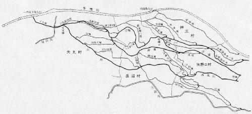
Course of the Omaru Irrigation Canal
The outline of the irrigation waterway is as follows. The intake was located at "Ichinoyama-shita" in Omaru (slightly upstream of the current Nambu Line Tamagawa Bridge). A water intake dam approximately 100 ken (about 182 meters) long was built on the Tamagawa River, and the water dammed here was taken in through a water gate (a gate for drawing in irrigation water) that was 2 ken (about 3.6 meters) wide. The water taken in first flows through the inner moat towards the distribution gate. The distribution gate was installed to separate the irrigation water for Omaru Village from that for other villages, with the width of the moat divided in a ratio of 1 for Omaru Village to 2 for other villages. The irrigation water for Omaru Village that was divided here is called Ohori, and after nourishing the southern part of Omaru Village, it flows through Naganuma Village and Yanokuchi Village, heading further towards Kawasaki. On the other hand, the irrigation water for other villages splits into Sugahori and Shinbori in the eastern part of Omaru Village. Shinbori flows across the central part of Naganuma Village, while Sugahori flows in a way that bypasses the northern part of the village, then heads towards Oshitachi Village, where it further divides into three streams at a point called Kenkaguchi. In this way, the irrigation water divided into several streams further branched out in a net-like pattern, nourishing the rice fields of the villages in the Kawasaki area downstream from Yanokuchi.
Villages Utilizing Irrigation Water
The areas that used the Omaru Irrigation Canal during the Edo period included four villages within the Inagi City area (Omaru Village, Naganuma Village, Oshitachi Village, and Yanokuchi Village) and five villages within the Kawasaki City area (Suge Village, Nakanoshima Village, Sugao Village, Gotanda Village, and Noborito Village). These villages spanned two districts, Tachibana District and Tama District, and were governed by different lords, but they were united in their use of the Omaru Irrigation Canal and organized the "Omaru Irrigation Canal Nine-Village Association." The most important task of this irrigation association was the maintenance and management of the irrigation waterway, including repairs to the irrigation moats themselves and facilities such as water intake dams and water gates. The materials used for these repairs were borne by each village. Additionally, disputes over water use frequently occurred. These water disputes varied, including conflicts over water distribution during summer droughts and the installation of water intake dams on the Tamagawa River. Each time, the villages appealed to the shogunate for adjudication.


Current Omaru Irrigation Canal
The Omaru Irrigation Canal, which has been maintained and managed since the Edo period, is gradually losing its function as agricultural irrigation water in modern times. The current management is carried out by the "Omaru Irrigation Canal Land Improvement District," established in August 1952, but the area of cultivated land using the irrigation water is decreasing year by year. Due to the reduction of rice paddies, the irrigation canals that have become unnecessary have been filled in, changing their appearance. However, recently, they have been newly developed as waterside parks and continue to live on as valuable waterfronts.
- Waterway Map of Omaru Irrigation Canal (Created from the Upper Volume of Inagi City History)
- Ancient Documents on Water Disputes (Sahoda Family Documents)
- Ancient Documents on Water Supply Repairs (Ashikawa Family Documents)
This page is managed by the Lifelong Learning Division, Department of Education
Inagi City Local History Museum
1-9-1 Hirao, Inagi City, Tokyo 206-0823
Phone number: 042-331-0660 Fax number: 042-331-0660
Inquiries to the Lifelong Learning Division, Department of Education, Inagi City